

Southwest Missouri tornado now being categorized as an EF-1
A section of Nevada, Missouri and nearby Moundville and other communities. are picking up the pieces after a tornado that ripped through the town early today.
A National Weather Service survey team found EF-1 tornado damage extending from southwest of Moundville to Nevada to northwest of Walker.
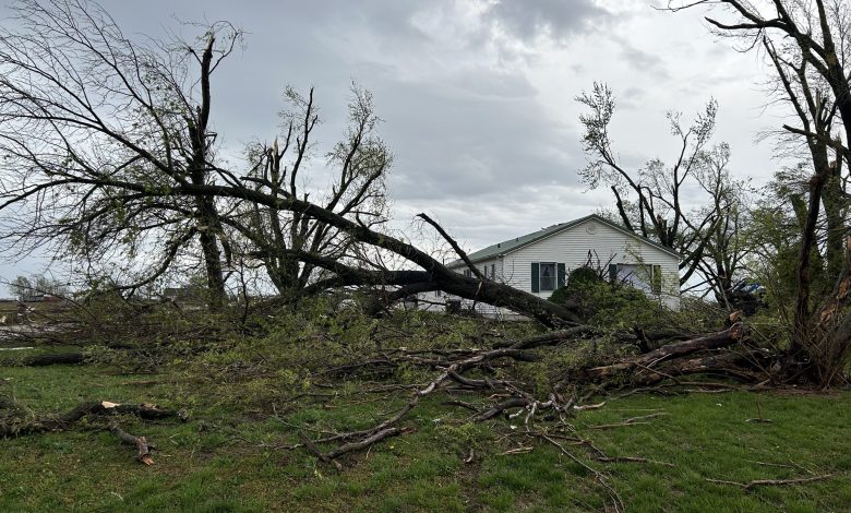
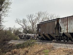
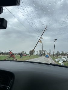
Eight train cars were knocked over, widespread tree damage was found, a few homes had roof damage, and numerous businesses suffered varying degrees of damage.
Numerous buildings and residences suffered damage in the storm that hit the area after the National Weather Service issued a tornado warning at 7:16 a.m.
Authorities say no fatalities were reported.
“We had one minor injury this morning when the storm came through,” explained Vernon County Emergency Manager, Derek White.
An unconfirmed report said the person was injured when a tree fell.
Some people may have driven to or walked into clinics for medical treatment.
“We made a secondary search of all the houses and the storm damage from the south end to the north end of the county to make sure we didn’t miss anything in the primary search,” Derek White added.
He said an important priority was getting power restored to the affected areas.
Numerous people took shelters in basements, safe rooms, shelters and, when necessary, interior rooms.
The Vernon County Sheriff’s office reported that first responders were deployed throughout the area to make a primary pass and to assess medical needs. Other agencies, including the Red Cross and Salvation Army were notified and were reportedly enroute shortly after the storm passed through.
There’s a volunteer station was reportedly set up at the Vernon county fairgrounds.
Nevada City Manager Gary Edwards attended meetings in the late morning and during the noon hour to discuss an overall damage review, to request an official disaster declaration from Missouri Gov. Mike Kehoe that would quality the Vernon County area for funding for clean up and recovery.
The National Weather Service of Springfield has reportedly arrived in Nevada to assess the damage and issue a report on the situation. Portions of this report will be added to this story once it is disseminated.
Storm sirens sounded in other communities including Joplin, Carthage and Webb City as the large squall line moved through the area.
The storm additionally affected southeast Kansas and northeast Oklahoma.
At NewsTalk KZRG, announcers Steve Scott, Ted Bojorquez, Ty Albright and Thom Watts provided real-time storm coverage with assistance from Geoff Maurer from the WeatherChannel.
During the next several days much of Missouri could be impacted by damaging severe storms and heavy rainfall. Dangerous and potentially historic rainfall is expected, especially across southeast Missouri. Flooding, and flash flooding, is possible over a large area of Missouri.
Driving Safety Tips
· Monitor your local forecast for severe weather and flood alerts.
· If you are traveling across the state, tune into area radio stations to monitor the forecast.
· Flash flooding can occur rapidly and be unpredictable. In a matter of minutes a roadway can become flooded.
· Pay attention while driving and anticipate the potential for flooded roadways in places you don’t expect it to be. During heavy or prolonged rainfall low lying areas of any roadway could become flooded, even on interstates and in towns.
· Be prepared for unexpected debris on the roadway.
· Never attempt to drive through flood waters. It only takes about 12 inches of swift moving water to sweep a vehicle away. The roadway could also be washed away.
· Never attempt to drive across downed power lines. If your vehicle comes into contact with downed power lines, remain in your vehicle and call for help.
· Slow down if traveling at night or during periods of reduced visibility. Reducing your speed provides you extra time to react to changing road conditions and reduces the risk of hydroplaning.
· Do not travel past or remove barricades closing a roadway. Drivers must respect barriers or barricades put in place by MoDOT. It is extremely dangerous and a violation of state law to drive around them.
Current road conditions and road closures can be found at the Missouri Department of Transportation’s Traveler Information Map.
The map can be downloaded from the app store for free to any smart device or you can visit it at https://traveler.modot.org/map/index.html. Road conditions can change often with flash floods or heavy rain. The map is updated regularly, but it is not possible to predict future road closings or water levels of specific rivers, lakes, or streams. Drivers are encouraged to check the map frequently for updates while traveling.
The Missouri State Highway Patrol encourages motorists to make good decisions to protect their safety. Choosing to travel into flood waters is dangerous.
Your choice puts the first responders who come to your aid in danger. If you experience a roadside emergency or see someone in need of aid, call 911 or *55 from your cell phone for assistance.