

Dry conditions continue to grip parts of the four-states
Scattered showers and thunderstorms over the past few weeks have kept drought conditions to a minimum in some parts of the KZRG listening area but other parts of the area are still dry. Read more from the National Weather Service below:
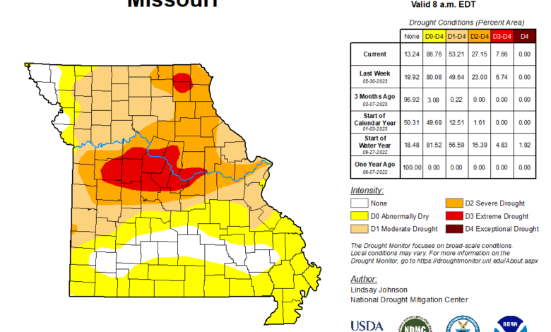
According to the latest U.S. Drought Monitor, Extreme (D3) Drought conditions remained unchanged across the northern half of Morgan County, northern Benton County and extreme northern Miller County in central Missouri.
Severe (D2) Drought remained unchanged over central and west-central Missouri as well as southeast Kansas. Locations in D2 Drought include the southern half of Morgan, northern Miller, central and southern Benton, northern St. Clair, extreme southwest Vernon, extreme northwest Barton Counties in Missouri and southern Bourbon and northern Crawford Counties in southeast Kansas.
This week`s area of Moderate (D1) drought remained relatively unchanged from the previous week. The D1 Drought area includes locations along and north of a line from Baxter Springs, Kansas to Lamar, Missouri to Osage Beach.
The area of Abnormally Dry (D0) classification also remained relatively unchanged. Areas within D0 include locations north of a line from Salem to Carthage and south of a line from Monett to Seymour to Summersville.
Precipitation…
Rainfall during the past week occurred unevenly across southeast Kansas and the Missouri Ozarks. Many locations east of a Gainesville to Salem line received little or no rainfall. Spotty locations west of this line received between one-tenth and one-half inch of rainfall. Isolated locations along and northwest of I-44 received over an inch of rainfall.
During the next seven days, most locations are expected to receive at least an inch of rainfall. Localized amounts exceeding two inches will occur.
Soil Moisture…
Surface soil moisture in the top several inches of the ground ranged from less than 2 percent over west central Missouri to over 30 percent across south central Missouri. Information courtesy of NASA-GRACE-Based Surface Soil Moisture Indicator.
Stream Conditions…
Average stream flows over the past seven days were near normal across most of southwest and south central Missouri, with below normal stream flows over most of central and west central Missouri and southeast Kansas. Information courtesy of the US Geological Survey.
Summary of Impacts…
Missouri Extension noted that producers were reporting low surface water in stock and farm ponds, and limited grass growth in the D2 and D3 Drought Areas. A few CMOR reports indicated limited forage, crop growth and soil moisture. Extension noted that initial corn growth looked yellowed, indicating limited root growth/health. Some crop planting has been delayed. Culling of herds has also been reported.
Drought Mitigation Actions…
The Missouri Department of Agriculture has an AgriStress Helpline at 833-897-2474, and University of Missouri Extension office has also set up a Psychological Service Clinic to aid farmers and ranchers.
Local Climate and Drought Outlook…
Over the next 8 to 14 days (June 15 – June 21), above normal temperatures are favored for the Missouri Ozarks and southeast Kansas. Equal chances for above, below and normal precipitation are expected over the entire area.
During the next 3 to 4 weeks (June 17 – June 30), above normal temperatures are favored for the Missouri Ozarks and extreme southeast Kansas. There is a slight signal for above normal precipitation, especially over southeast Kansas and southwest Missouri.
For the period June-August, near to above normal temperatures are favored and above normal precipitation is favored. The current areas of drought are expected to slowly improve or be removed from drought status.

